UN Votes to Replace Mercator Map with Equal Earth Projection
The UN General Assembly has adopted a resolution to phase out the Mercator map, aiming for a more accurate representation of Africa's size.
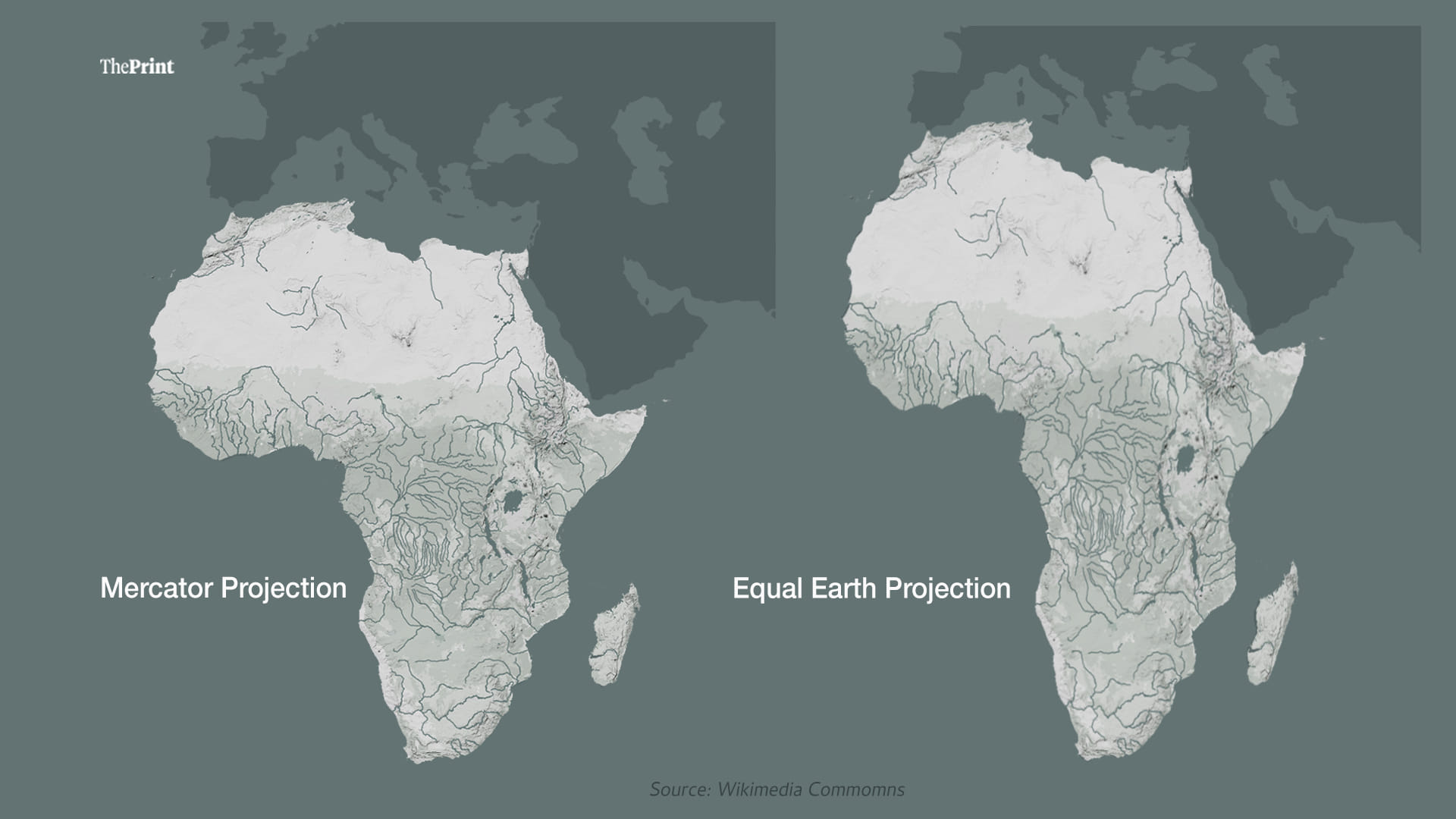
The UNGA has officially retired the Mercator map, which has been in use since the 16th century.
The resolution received support from 164 countries, with the US being the only nation to oppose it.
The shift to the Equal Earth projection aims to address historical inaccuracies in global cartography.
In a significant move, the United Nations General Assembly (UNGA) has voted to adopt a new global map that aims to provide a more accurate representation of Africa's size. This resolution marks the formal retirement of the Mercator map, which has dominated cartography for over 450 years. The decision was made during a recent session of the UNGA, with India and 163 other nations supporting the resolution, while the United States stood alone in opposition.
The Mercator projection, created in the 16th century, has long been criticized for distorting the sizes of continents, particularly Africa, which appears much smaller than it actually is. The resolution, championed by Togo on behalf of the African Union, emphasizes the need for maps that reflect true geographical dimensions. Togo's Foreign Minister, Robert Dussey, highlighted that the current projections contribute to a skewed perception of global geography, which can affect education and cultural understanding.
Despite the non-binding nature of UNGA resolutions, the passage of this one is expected to encourage the adoption of more accurate maps worldwide. The US, however, expressed strong disapproval, claiming that the resolution undermines the credibility of the UN. The American delegation argued that the initiative is part of a broader ideological agenda, suggesting that it distracts from the institution's core mission. This stance aligns with previous actions taken under the Trump administration, which included rebranding geographic features to reflect a more nationalistic perspective.
The implications of this resolution extend beyond mere cartography. As technology continues to evolve, the demand for accurate mapping in digital applications has surged. Major platforms like Google Maps and Apple Maps utilize versions of the Mercator projection, which could be impacted by this new resolution. The UNGA has called for tech companies to engage in discussions aimed at promoting accurate representations of geographical data, including the Equal Earth projection.
Looking ahead, the resolution encourages nations to explore various cartographic methods that preserve the relative sizes of landmasses. While the French government has already committed to abandoning the Mercator projection, the adoption of the Equal Earth projection remains at the discretion of individual countries. The UNGA's decision could lead to a broader reevaluation of how maps are created and used, potentially reshaping global perceptions of geography in the years to come.